Best Colorado National Monument Hikes: 10 Trails Worth Your Time
Add these can’t-miss Colorado National Monument hikes to your bucket list — you won’t regret it.
Looking for the best Colorado National Monument hikes? After living in Grand Junction for nearly a decade, I’ve hiked every trail on this list, some dozens of times. Whether you’re looking for an easy overlook, a challenging canyon adventure, or only have a few hours to explore, this guide will help you choose the right hike without wasting time.
Whether you live in Grand Junction or are just stopping through on your way to Arches National Park or another destination, hiking in Colorado National Monument is must-do activity.
➡️ Hike Great Sand Dunes National Park or the Maroon Bells Crater Lake trail for more Colorado adventures.
You’ll find this hiking guide offers indispensable knowledge about customizing trekking routes, directions for finding the trailheads, and critical trail information. It can be easy to miss a turn and get lost on some of these trails.
➡️ Discover more trails on my Colorado outdoor guide.
Colorado National Monument is one of the most extraordinary places to hike in Grand Junction.
Disclosure: This post may contain affiliate links. If you purchase through these links, I may earn a small commission at no extra cost to you. I only recommend products I’ve personally used, tested, and genuinely love. Thank you for supporting Emma Gets Outside!
Best Colorado National Monument Hikes at a Glance
Here’s a quick comparison of the most popular hikes in Colorado National Monument to help you choose the best trail for your skill level.
| Trail Name | Distance | Difficulty |
|---|---|---|
| Devil’s Kitchen | 1.1 mi | Moderate |
| No Thoroughfare Canon | 5.6 mi | Moderate |
| Echo Canyon | 2.6 mi | Moderate |
| Serpent’s Trail | 3.8 mi | Moderate |
| Liberty Cap | 3 mi | Moderate |
| Ute Canyon | 11.2 mi | Hard |
| Otto’s Tub | 8.6 mi | Moderate |
| Bench Route | 11.1 mi | Hard |
| Monument Canyon | 4.5 mi | Moderate |
| Otto’s Trail | 0.7 mi | Easy |
Colorado National Monument Itinerary
If you’re driving through Colorado National Monument on your way to somewhere else or have a limited time, I recommend hiking Echo Canyon (right at the Grand Junction entrance) and then driving Rim Rock Drive to Fruita. Stop to hike Otto’s Trail along the way if you have time.
If you’re a Grand Valley local looking for solitude, definitely check out the Bench Route. You’ll need to be an experienced hiker to attempt this trail. Otto’s Tub Trail also has few people on it with scenic views at the end.
Try Serpent’s Trail or Liberty Cap Trail for some elevation gain and a workout. The Monument Canyon Trail also features some gain with incredible views of the Independence Monument.
Read the trail descriptions and tips provided throughout this post to plan your ideal Colorado National Monument experience!

Devils Kitchen Parking Area in Colorado National Monument
First, a note about the Devils Kitchen parking area — it’s small! As you enter Colorado National Monument on Monument Road from Grand Junction, you’ll see the Devils Kitchen parking lot on the left and a sign on the right for the Devils Picnic Area.
There are restrooms located at the Picnic Area, and you can park there as well. If the Devils Kitchen lot is full, parking at the Picnic Area is your best bet.
You’ll see a sign that says “To Serpents Trail” off of the Picnic parking lot that leads to a trail that will get you to the Devils Kitchen parking area, or you can follow the road back down to the other lot.
There are several trails you can access from this area, and it’s close to town if you’re looking for a quick and easy adventure.
Trails in Colorado National Monument accessed from the Devils Kitchen parking area:
- Devils Kitchen Trail
- No Thoroughfare Canyon
- Echo Canyon
- Serpents Trail
- Old Gordon Trail
Devils Kitchen Hiking Trails Map
Directions to the Devils Kitchen parking area: Devils Kitchen Trail, Serpents Trail, Grand Junction, CO 81507
The Devils Kitchen Trail is highlighted on the map, but you can also see the other trails that branch off of it. Zoom in to see trail names and get a better understanding of how these hikes are connected.
At the first fork of the Devils Kitchen Trail, you’ll see the path on the left that splits again later into the Old Gordon Trail and Echo Canyon.
If you continue on the Devils Kitchen Trail and bypass the Echo Canyon/Old Gordon split, you can access No Thoroughfare Canyon or hike all the way to the end of Devils Kitchen.
The Serpents Trail trailhead is just across the street from the Devils Kitchen trailhead. You’ll know you’re in the right spot when the trail starts switchbacking right off the bat.
Everything is pretty well marked to help you find the hike you’re aiming to do — but it also never hurts to have the AllTrails map downloaded if you are an AllTrails Plus subscriber.

Devil’s Kitchen Trail
A Fun and Short Trail in Colorado National Monument
Devils Kitchen Stats:
1.1 mi | 269 ft gain | Out & Back
Moderate Difficulty
Devils Kitchen Trail Map
A fun and rewarding hike, the Devils Kitchen Trail is short and requires a bit of scrambling if you want to get to the highest point in the Kitchen area. I consider it one of the most easy hikes near Grand Junction.
From the parking lot, you’ll start with a quick descent and go right at the split with Echo Canyon. There will be another sign indicating the split between Devils Kitchen and No Thoroughfare Canyon; follow the trail left.
The trail is well-marked with signage until you are right below the cluster of rocks that make up the Devils Kitchen, then the trail becomes less obvious. Follow the cairns and stay on the rocks to avoid stepping on any cryptobiotic soil crust.
At the top, you’re met with an impressive view looking down through No Thoroughfare Canyon. Watch for herds of bighorn sheep and glance towards Rim Rock Drive to see cars driving up and down the switchbacks.

No Thoroughfare Canyon
See a Seasonal Waterfall on Your Hike in Colorado National Monument
No Thoroughfare Canyon Stats:
5.6 mi | 793 ft gain | Out & Back
Moderate Difficulty
No Thoroughfare Canyon Map
You can easily add the Devils Kitchen Trail onto the No Thoroughfare Canyon hike if you want a little side adventure. Just follow the signs for Devils Kitchen and then retrace your steps back to the trail junction with No Thoroughfare.
Much of this trail is in a wash — you’ll need to navigate around small boulders and watch your step to not catch your ankle in a bad spot. If you struggle with stability, I would bring hiking poles on this trail.
There are seasonal waterfalls in No Thoroughfare Canyon, the maintained trail leads to the first falls, but an unmarked technical route continues up. Most hikers choose to turn around here.
The waterfalls only flow when there’s enough rain or snowmelt to sustain them. Late winter or early spring is your best bet to see them flowing.

Echo Canyon
One of My Personal Favorite Hikes in Colorado National Monument
Echo Canyon Stats:
2.6 mi | 518 ft gain | Out & Back
Moderate Difficulty
Echo Canyon Map
Take the first split off of the Devils Kitchen Trail and go left. The trail runs parallel to private property. You’ll encounter another trail split later, go left again, descending along a fence line. The Old Gordon Trail starts ascending at the fork, so if you’re hiking uphill, turn around!
This is when the hike enters the canyon and the scenery becomes immersive. Look up at the Cottonwood trees and admire the towering canyon walls.
There are fun features to spot within the canyon and excellent shade at certain times of day. Follow the trail to the end of the canyon and then turn around.
Echo Canyon is one of my favorite little hikes in Colorado National Monument. The trail is short and sweet with moderate elevation to get your heart pumping.
Serpents Trail
Incredible Views from the Colorado National Monument
Serpents Trail Stats:
3.8 mi | 797 ft gain | Out & Back
Moderate Difficulty
Serpents Trail Map
If you’re looking for a workout, Serpents Trail is a fantastic training trail. I’ve done it countless times throughout the year (even in January). The moderate grade and wide width of the trail make it popular with seasoned trail runners and novice hikers alike.
It’s a hike I’ve repeated more times than any other trail I’ve done. There are views the entire way up, and you can stop to look over the edge. Marvel at the winding Rim Rock Drive and appreciate the expansive views of Grand Junction.
You can park at the top of Serpents Trail, though there is only room for about three cars. If you want a challenge, you can park at the top and descend the trail first before heading back up to your vehicle.
My favorite time of day to hike Serpents Trail is sunset. The Bookcliffs light up pink and the trail is mostly in the shade. It’s one of the more popular hikes near Grand Junction for a reason!
Liberty Cap Hiking Trails Map
Directions to Lower Liberty Cap trailhead (Wildwood trailhead): 2110 Wildwood Ct, Grand Junction, CO 81507
Directions to Upper Liberty Cap trailhead: 3747+66, Grand Junction, CO 81507
Just like at the Devils Kitchen Area, the Liberty Cap Trail branches off into a few different hikes and can be a bit confusing.
You can park at the Upper Liberty Cap trailhead off of Rim Rock Drive (I’d recommend that for getting onto the Ottos Tub route), or you can park down below at the Wildwood trailhead (also known as Lower Liberty Cap trailhead).
If your goal is to hike to the top of Liberty Cap or follow the Ute Canyon trail, definitely park at the lower trailhead. Zoom in on the map to see the trail names for a comprehensive view.
Colorado National Monument hiking trails accessed from the Liberty Cap Trail:
- Liberty Cap
- Ute Canyon
- Ottos Tub
Liberty Cap Trail
One of the Steeper Colorado Monument Hikes
Liberty Cap Trail Stats:
From the Lower trailhead:
3 mi | 1,125 ft gain | Out & Back
Moderate Difficulty
Liberty Cap Trail Map
From the Lower trailhead with the Corkscrew Trail:
≈ 4.2 mi | 1,125 ft gain | Loop
Moderate Difficulty
Liberty Cap is one of the steeper Colorado National Monument hikes. It’s an excellent trail for quick elevation gain to a stunning view.
Gaining over 1,100 feet in a mile and a half is no joke. Some parts of the trail are at a large angle with loose rocks, so watch your foot placement.
I’d highly recommend bringing hiking poles. There are several rock stair structures on the trail that help, but they don’t leave room for much error with your footing.
If you want to avoid the steepest parts on the way down, take the Corkscrew Trail. It adds a milder mile to the hike, and you get to see different views. You can of course, just take the Liberty Cap Trail down, but your knees will thank you if you take the Corkscrew instead.
To access the Corkscrew Trail, hop on the Ute Canyon Trail about 0.6 miles from the top of Liberty Cap. Follow the Ute Canyon Trail for a little while, then you’ll make a left to go down the Corkscrew.
If you followed the Ute Canyon Trail, you’d end up in, you guessed it, Ute Canyon.

Ute Canyon Trail
Spot an Arch in Colorado National Monument
Directions to the Upper Ute Canyon trailhead: Ute Canyon Trail, Grand Junction, CO 81507
Ute Canyon Trail Stats:
Full Trail:
11.2 mi | 2,014 ft gain | Out & Back
Hard Difficulty
Ute Canyon Trail Map
There are a few options when it comes to hiking Ute Canyon. You can park at the Ute Canyon Upper trailhead along Rim Rock Drive and descend one-way to the Lower Liberty Cap trailhead. This requires you to have a friend pick you up at the bottom (or drop you off at the top) or shuttle a vehicle — leave one vehicle down below and drive the other to the top, then drive back up to collect the other car after the hike.
Or, you can do the whole hike from start to finish as an out-and-back (in that case, I’d recommend parking at the bottom so the second half of your hike feels easier rather than trudging uphill to get back to Rim Rock Drive after 10 miles).
Or, the last option, if 11 miles and 2,000 feet of gain sounds more like self-inflicted torment than a good time, you can go halfway into the canyon and turn around — still completing a considerable hike of 5-6 miles.
Access to Ute Canyon From The Lower Liberty Cap Trailhead:
At about one mile from the Lower Liberty Cap trailhead, after the steep slog section, you can turn off to Ute Canyon. There are signs along the trail, but have a map downloaded to ensure you don’t miss the turn.
Follow the trail to arrive at a secluded canyon with stunning rock formations. Keep your eyes peeled for an arch. There isn’t much shade except for what a few piñon and junipers provide.
Hike all the way to the rim and back, or choose to go as far as you’d like and turn around. Consider taking the Corkscrew Trail on your way down to avoid the slipperiest sections of trail.

Ottos Tub Trail
Find Solitude in the Monument
Ottos Tub Trail Stats:
From the Upper Liberty Cap trailhead:
8.5 mi | 672 ft gain | Out & Back
Moderate Difficulty
Ottos Tub Trail Map
From the Lower Liberty Cap trailhead:
≈ 5.3 mi | ≈ 1,604 ft gain | Out & Back
Moderate Difficulty
Ottos Tub offers substantial views as it traverses along the rim of yet another canyon. As far as Colorado National Monument hiking trails go, it’s one of the more peaceful and moderate elevation gain treks.
You can access Ottos Tub from the Upper or Lower Liberty Cap trailheads. It’s about halfway on the Liberty Cap Trail, approximately 3.3 miles from either trailhead.
If you want to feel some pain… I mean, gain… start from the Lower trailhead. Starting from the Upper trailhead offers more solitude and a gentle trek through a piñon and juniper forest to the Ottos Tub turn-off.
Have a map downloaded! I almost missed the turn-off, and even when I found it, it wasn’t very obvious. There is no sign indicating where the Ottos Tub Trail begins.
The “trail” turns to rock, so there isn’t a clear path leading out to the Tub. Be sure to follow the map so you can find the Tub.
Ottos Tub Trail has some of the most unique views out of all the Colorado National Monument hikes because it’s out on a peninsula and you are looking back at the Monument rather than out at the Grand Valley.
Bench Route Map
Directions to start the Bench Route: Goldstar Trailhead, Grand Junction, CO 81507
The Bench Route is yet another build-your-own hike kind of trail. Parking is available at the Goldstar trailhead, located off South Broadway. You won’t find a lot of space, but this trail isn’t very popular.
It is absolutely critical that you have a map downloaded and solid route-finding skills to complete this trail. There are no signs, and parts of the trail can get washed out with rain. Other trails also stem off the Bench Route, so you’ll need to know which trail to follow.
I had to consult my map several times while hiking, as there wasn’t even a set of footprints to follow due to recent rain.
Bench Route Trail
For Experience Hikers Only
Bench Route Stats:
Looping with the Corkscrew Trail:
11.1 mi | 1,893 ft gain | Loop
Hard Difficulty
Bench Route Map
One-way with Corkscrew Trail back to Lower Liberty Cap trailhead:
≈ 7 mi | ≈ 1,300 ft gain | One-way
Moderate Difficulty
One-way descending Liberty Cap Trail to Lower Liberty Cap trailhead:
≈ 5.7 mi | ≈ 1,300 ft gain | One-way
Moderate Difficulty
The first half mile climbs around 400 feet and has you questioning your life choices. It’s extremely steep, lacking improved structures. Once you make it to the “Bench,” the trail mellows out and continues with smaller elevation changes.
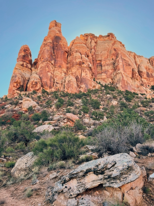
The Bench Route runs below several rock towers that are quite imposing. Take time to observe nooks and crannies in the rock faces. There wasn’t much shade in the morning, but more parts of the hike would be shaded in the evening.
After about 4.7 miles, you’ll pop out onto the Liberty Cap trail. Here, you’ll have to make a choice. Start your descent to the Lower Liberty Cap trailhead via the Corkscrew Trail or the Liberty Cap Trail — or you can loop the Corkscrew Trail to bring you back onto the Bench Route and go back to the Goldstar trailhead, where you started.
Have a friend drop you off or pick you up to make the hike one-way. I opted to do this and have no regrets. Going down the steep, unimproved section back near the Goldstar trailhead didn’t spark enthusiasm from me, but if technical downhills are your thing, go for it.
If you desire an adventure, the Bench Route provides that and more. It’s one of the most primitive Colorado National Monument hikes.

Monument Canyon Trail
A Colorado National Monument Gem
Directions to Monument Canyon Trailhead: 1810, 1898 CO-340, Grand Junction, CO 81507
Monument Canyon Trail Stats:
Loop with Wedding Canyon:
4.5 mi | 767 ft gain | Loop
Moderate Difficulty
Monument Canyon Trail Map
Hiking Monument Canyon Only:
≈ 4.4 mi | ≈ 560 ft gain | Out & Back
Moderate Difficulty
This Colorado National Monument hike is more straightforward than some of the others on here, so I didn’t include a map for viewing, but you can still click on the AllTrails link for a map below where the trail mileage is listed.
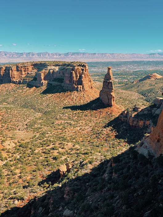
Monument Canyon leads to the iconic Independence Monument, the crown jewel of Colorado National Monument. Topping many people’s lists of one of the best hikes in Grand Junction.
If you choose to make the trail a loop with Wedding Canyon, I’d recommend starting in Wedding Canyon first and then taking Monument Canyon back to the car.
Wedding Canyon is much steeper and unimproved. Monument Canyon has lots of stairs built into the trail that make descending a breeze. I’ve done it both ways, and it’s definitely more enjoyable to start with Wedding Canyon, making the hike feel shorter than it is.
Wedding Canyon is also shaded if you go in the morning, ideal for breaking a sweat on the ascent and descending later in the sunny Monument Canyon.
If you don’t want to make a loop, you can always do Monument Canyon only out and back. It does reduce some of the gain, but you miss out on more scenery and don’t really save any mileage.
I’ve seen bighorn sheep walking high above on the cliff edges, so be on the lookout during your hike.
Getting up close to Independence Monument is such a different experience from seeing it from one of the many overlooks above on Rim Rock Drive. You get a much better idea of its sheer size.

Ottos Trail
Easiest Trail in Colorado National Monument
Directions to the trailhead: Otto’s Trail, Colorado 81507
Ottos Trail Stats:
0.7 mi | 111 ft gain | Out & Back
Easy Difficulty
Ottos Trail Map
I definitely consider Ottos Trail to be more of an easy stroll to a lookout point more than a hike — especially compared to the rest of the trails on this list.
That being said, don’t discount the experience this trail can give you. Go at sunset to admire the rocks turn orange under the last rays of sun.
Plus, Ottos Trail is a mere mile drive from the Saddlehorn Visitor Center. If they’re open, you can learn more about Colorado National Monument from a park ranger or purchase a sticker to commemorate your time in the Monument.
Another notable bonus, Ottos Trail provides a welcome reprieve from being in the car if you choose to drive the entire 23-mile Rim Rock Drive. Grand View Point is my favorite overlook along the drive, and Cold Shivers Point is also worth a stop.
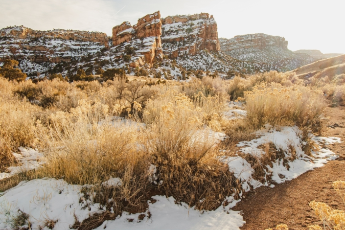
Colorado National Monument hikes are truly stunning in every season — even perfect for winter hiking. I’ve hiked during every month of the year in Grand Junction and there’s something to appreciate about each unique season.
Before Hiking in Colorado National Monument
Invest in a National Parks Pass
There is an entry fee to access Colorado National Monument. You can pay for a one-day entrance pass, but I’d highly recommend you invest in an America the Beautiful Pass.
The America the Beautiful Pass will give you access to every National Park and National Monument in the country (valid for a year from the month of purchase). Plus, it covers fees for over 2,000 recreation areas all across the United States.
As a pass holder, you can get discounts on eligible campsites and permits. Sounds like a great deal to me!
Be a Prepared Hiker
Even on short hikes, it’s smart to be a prepared hiker. Read my article about what items should be on your day hike packing list, and as always, Leave No Trace.
Check weather conditions before you head out and tell someone where you’re going. Grand Junction can get quite hot in the summer months, so plan accordingly with your water supply.
Wear long sleeves or bring sunscreen to cover your exposed skin. You can burn easily in the high desert environment. A merino wool shirt and socks will wick sweat and leave you more comfortable than hiking in cotton or synthetic.

📌 Pin this image on Pinterest to save this post for reference.
FAQs About Colorado National Monument Hikes
What are the best hikes in Colorado National Monument?
Some of the best hikes in Colorado National Monument include Serpent's Trail, Devil’s Kitchen Trail, Monument Canyon Trail, and the Bench Route. Serpents Trail is a local favorite for steady switchbacks and sweeping canyon views, while Monument Canyon offers a longer, more rugged backcountry experience.
Do you need a pass to hike in Colorado National Monument?
Yes. Colorado National Monument requires an entrance pass. You can purchase a pass at the entrance station, or use an America the Beautiful annual pass if you have one. No separate hiking permit is required for day hikes.
When is the best time to hike in Colorado National Monument?
Spring and fall are the best seasons to hike in Colorado National Monument. Temperatures are milder, making longer hikes more enjoyable. Summer can be very hot, especially in exposed canyon sections, so start early and bring plenty of water.
How difficult are the hikes in Colorado National Monument?
Hikes range from easy nature trails to strenuous canyon routes. Most popular trails are moderate and suitable for hikers with basic fitness. Longer trails require more endurance and preparation.